![]() |
This site is not affiliated with AGCO Inc., Duluth GA., Allis-Chalmers Co., Milwaukee, WI., or any surviving or related corporate entity. All trademarks remain the property of their respective owners. All information presented herein should be considered the result of an un-moderated public forum with no responsibility for its accuracy or usability assumed by the users and sponsors of this site or any corporate entity. | |||||
| The Forum | Parts and Services | Unofficial Allis Store | Tractor Shows | Serial Numbers | History | |
Church Houses that I See |
Post Reply
|
| Author | |
BuckSkin
Orange Level
Joined: 12 Sep 2019 Location: Poor Farm Points: 1114 |
Post Options
Thanks(0)
Quote Reply
Topic: Church Houses that I SeePosted: 08 Sep 2025 at 12:11am |
|
Bethany Baptist Church As Seen on Aaron Roberts Tractor Trail Ride_2024 Northbound on KY1675 Between Acorn-Ano Road and Farmer Road KY1675 North/West of Sandy Gap Road is old KY Hwy 80 South side of KY Hwy 80 in Pulaski County KY1675 - Shopville - Pulaski County - Kentucky Saturday_08-June-2024 This church was a landmark on Kentucky Highway 80 until they re-routed the highway. Centerline to centerline, the new KY Hwy 80 is exactly 0.95-mile straight North of this old routing.(Right of the photos) West side of KY1675 at Mile 8.11 at the Farmer Road Junction 37° 9'6.58" North Parallel 84°23'33.31" West Meridian Elevation 901' |
|
![]() |
|
| Sponsored Links | |
![]() |
|
LouSWPA
Orange Level Access
Joined: 11 Sep 2009 Location: Clinton, Pa Points: 25413 |
Post Options
Thanks(1)
Quote Reply
Posted: 08 Sep 2025 at 10:54am |
|
Interesting that you should refer to the building as a church house. Few people recognize the significance of that. The church is the people, the congregation, the building is just that, a roof for the church to gather under.
|
|
|
I am still confident of this;
I will see the goodness of the Lord in the land of the living. Wait for the Lord; be strong and take heart and wait for the Lord. Ps 27 |
|
![]() |
|
jdeere562
Bronze Level
Joined: 02 Oct 2023 Location: SW Iowa Points: 47 |
Post Options
Thanks(0)
Quote Reply
Posted: 09 Sep 2025 at 11:51am |
|
This is a converted church not far from here. https://www.zillow.com/b/412-maple-st-henderson-ia-9HDJCh/
|
|
![]() |
|
Coke-in-MN
Orange Level Access
Joined: 12 Sep 2009 Location: Afton MN Points: 42167 |
Post Options
Thanks(0)
Quote Reply
Posted: 13 Sep 2025 at 3:13pm |
|
Church House I would call the PARSONAGE from the churches of the past .
A Parsonage was there as living quarters for the Pastor or Spiritual Leader of Congregation . Many times as part of compensation for serving . |
|
|
Life lesson: If you’re being chased by a lion, you’re on a horse, to the left of you is a giraffe and on the right is a unicorn, what do you do? You stop drinking and get off the carousel.
|
|
![]() |
|
BuckSkin
Orange Level
Joined: 12 Sep 2019 Location: Poor Farm Points: 1114 |
Post Options
Thanks(0)
Quote Reply
Posted: 01 Dec 2025 at 2:15am |
|
Saturday_07-June-2025 As Seen on Aaron Roberts Tractor Trail Ride_2025 Sinking Valley Baptist Church Originated in 1812 North side of Public Road at Hawk Road North side of KY Hwy 80 in Pulaski County KY1677 - Shopville - Pulaski County - Kentucky 37°10'52.76" North Parallel 84°23'20.50" West Meridian 1,116' Above Sea Level
|
|
![]() |
|
BuckSkin
Orange Level
Joined: 12 Sep 2019 Location: Poor Farm Points: 1114 |
Post Options
Thanks(0)
Quote Reply
Posted: 58 minutes ago at 2:40am |
|
Thursday_01-January-2026 
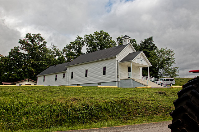
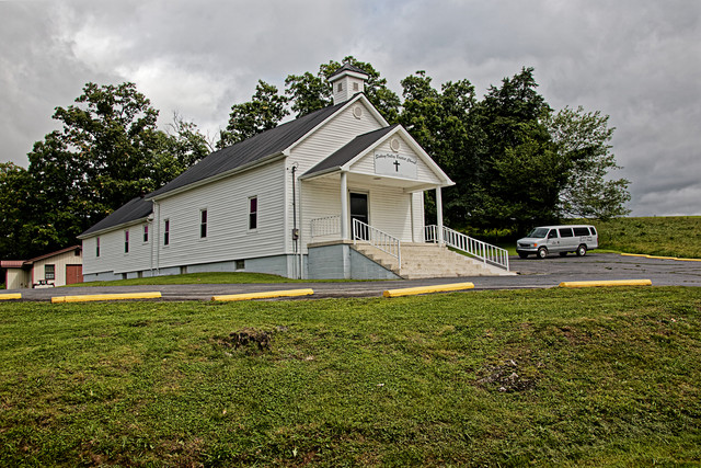
Established in 1831, this church and building was originally located in the Half Acre community on Lily Creek. In the early 1900's, the building was moved to it's current location; to appreciate the difficulty in this, you should familiarize yourself with the location, narrow crooked roads, and steep terrain of Lily Creek on Half Acre Road; there is no good way in or out of there. If I am not mistaken, between the weatherboard exterior and solid wood interior panelling, the actual structure of this church is a log building; in which case, they probably just numbered the logs, disassembled the building, moved the logs, and put it all back together; if you doubt the log construction, go there and take notice of how thick the walls are. The Sunday school rooms annex on the rear was added in the 1940's; the original 1940s Sunday School rooms did not exceed the width of the main building as they do now. Up until the mid-1980s, this church was surrounded on three sides by thick Beech woods for a couple hundred yards in each direction; within twenty feet of the back wall; within sixty feet of the North wall; and, the South corner of Airport Road was big timber right up to the corner. On the South side, that is now naked black-top parking, were a grove of big shade trees; I don't see a tree or a bush on the property now. Widening and straightening US Hwy 127 took away a lot of the front yard and put the edge of the road and sidewalk almost in the front door. West side of US Hwy 127 - North of Union Underwear US Hwy 127__Mile Marker #15.33 Russell Springs - Russell County - Kentucky 37° 0'54.48" North Parallel - 85° 4'33.93" West Meridian 986' Above Sea Level Photo taken through the glass of a moving vehicle. |
|
![]() |
|
Post Reply
|
|
|
Tweet
|
| Forum Jump | Forum Permissions ![]() You cannot post new topics in this forum You cannot reply to topics in this forum You cannot delete your posts in this forum You cannot edit your posts in this forum You cannot create polls in this forum You cannot vote in polls in this forum |